Changing the FOV/FOI Viewing Default
The FOV/FOI Viewing Default refers to what appears in the 3D window of Detect3D, i.e. if a risk grade with a 10 meter gas cloud is set as the FOI Viewing Default then all the gas detectors in the 3D window will appear with a 10 meter gas cloud. This does not mean the coverage results will change when a new risk grade is made as the viewing default. Coverage results are calculated based on the risk grade assigned to the associated zone or sub-zone, regardless of what is showing in the 3D window. This means that coverage results for a sub-zone can be calculated based on a 5 meter gas cloud when the 3D window is showing a 10 meter gas cloud.
The contours for gas mapping will always display the gas cloud size for the risk grade having the FOV/FOI Viewing Default.
It is important to keep note of which risk grade is assigned to which zone/sub-zone as some projects could have many risk grades. To help with this, the colored boxes next to the zone name will always match the color assigned to the risk grade. This will also be apparent in the coverage results table. For some projects though, it may be beneficial to have only one risk grade to avoid confusion of what gas cloud size is applied where.
To change the FOV/FOI Viewing Default:
-
Turn on the FOI visibility of the point and open-path gas detectors, if they are not already. Note that the gas cloud size from the Tutorial 2.d3d file is currently 10 meters, seen below.

Tutorial 6 - Figure 03 - Gas detectors with the 10m gas cloud size for the Default Grade
-
Make note that the Main Gas Zone has the Default Grade assigned. The Default Grade's gray color, indicating that risk grade was applied, is shown in the project items tab and the coverage results window. To reiteratie, the coverage results for the Main Gas Zone will remain based on the size of the gas cloud defined in the Default Grade regardless of what appears in the 3D window, as long as the Default Grade is applied. At the moment the 1ooN coverage for the project is 87.1% 1ooN and 34.3% 2ooN.
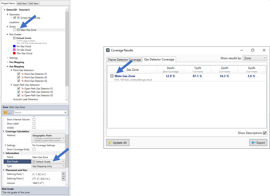
Tutorial 6 - Figure 04 - Showing the current coverage calculation for the Main Gas Zone with the Default Grade assigned
-
Make the 5m Gas Cloud risk grade the viewing default by right-clicking its name in the Project Items Tree and selecting FOVI/FOI Viewing Default as shown below.
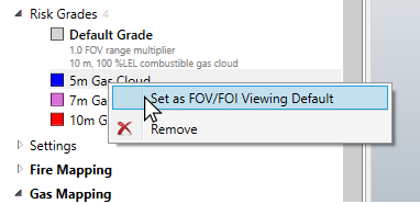
Tutorial 6 - Figure 05 - Changing the Visible Risk Grade
-
Upon selection, the 3D window will update to display the properties of the chosen risk grade. The window should now appear similar to Figure 6 with the 5m gas cloud size applied. It is also shown that the coverage results for the Main Gas Zone has not changed, since the zone is still referencing the gas cloud size of the Default Grade.

Tutorial 6 - Figure 06 - Updated 3D window with 5m Gas Cloud Risk Grade Visible
This section has focused on the changing the FOVI/FOI Viewing Default which affects the 3D window and contours. Doing this has not affected the coverage results for the zone. The next section will go over the opposite situation - changing the risk grade assigned to the zone, which will affect the coverage calculation but not the 3D window.